MOVING THE CONTINENTS; CREATING THE OCEANS
Ours is the blue planet, just as Mars is the red planet. Spectacular
photos taken from space confirm the color of our planet beyond
any doubt. It is not entirely blue, of course: there are splotches
of brown in arid land areas, greens in areas of dense vegetative
growth, the brilliant whiteness of ice in the polar regions, the
white swirls of clouds. But mostly it is blue, because of the
blue vastness of the oceans.
Oceans cover more than 70% of the Earth's
surface. In fact, as author Brad Matsen and artist Ray Troll have
pointed out (Matsen and Troll, 1994), an appropriate name for
our planet is Planet Ocean. (The term Planet Oceanus has also
been used: Pinet, 1992.) We ourselves, being land dwellers (except
for those who sail the oceans or make our livings by ocean fishing),
tend to forget this fact. It is a fact that makes our planet unique
in the solar system and probably quite rare even among the extrasolar
planets (those outside our own solar system) that we are likely
to discover.
Earth's liquid water is stored in the
low-lying parts ("basins," to the geologist) of the
planet's surface, as oceans, seas, and, on land, lakes. Though
this is obvious, as water always flows to the lowest point (indeed,
in classical times the "element" water was thought to
be heavier than the "element" earth because it "sought"
-- that is, flowed down to -- the lowest ground, while most other
things made of earth, including rocks, did not), the existence
of such basins is not something that ought be taken for granted.
After all, as those who study lakes (they're
called limnologists) well know, lakes are always filling in with
sediment and ceasing to exist. Those who have visited Yosemite
Valley in Yosemite National Park may also know this, as within
the past several decades, much of that which used to be Mirror
Lake, under the towering face of Half Dome, has filled in and
become the grassy Muir Meadow. Such filling is the ultimate fate
of all lakes.
The same fate should also befall oceans
(and their smaller cousins, seas). Over many tens and hundreds
of millions of years, sediment, washed from the land by rivers,
ought to fill them up. And certainly there has been enough time
for that to have happened. But it hasn't. Why not? Why does Earth,
after all these billions of years, still have ocean basins?
Ocean basins exist because of what earth
scientists call plate tectonics. Tecton was the name of a carpenter,
mentioned in Book 5 of Homer's Iliad as the father of Phereclus,
who built the Trojan fleet. Tecton, in fact, means carpenter in
Greek. The term tectonics derives from the work of a carpenter,
carpentry, or, more generally, construction. Geologists use the
term tectonics to refer to the large-scale forces and movements
that construct and shape the crust of the Earth. The general term
tectonics includes things like earthquakes and the folding and
faulting of Earth's rocky surface. Plate tectonics, however, specifically
refers to the movement of the enormous plates which comprise that
surface, like large tiles covering a kitchen floor.
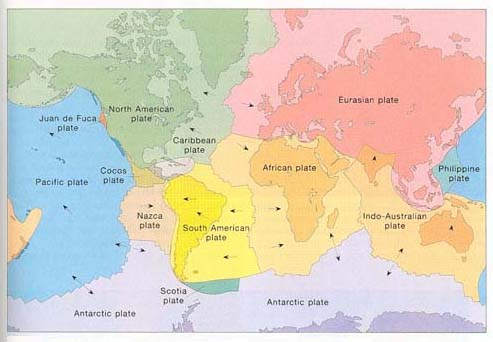
Earth's tectonic plates.
The surface of the Earth is comprised of several large tectonic
plates, and numerous small ones. Most plates include both continent
(darker colors), and adjacent ocean floor (lighter colors). The
Cocos, Philippines, Juan de Fuca, and Nazca plates all are oceanic
plates; the Pacific plate (the largest; the Antarctic plate looks
larger, but that is just map distortion), includes some tiny slivers
of land in addition to volcanoes; the Caribbean and Scotia plates
also possess volcanoes. The arrows show the general direction
of relative plate movements. Where arrows at plate boundaries
point away from each other, they indicate mid-ocean ridges, where
ocean floor is being created. (Levin, 1991)
The largest of these plates are thousands
of kilometers (a kilometer = 0.6 mile) across; the smallest (called
"microplates") are mere slivers, perhaps a few hundred
kilometers long but only a few tens of kilometers across. (One
such sliver is believed to be a microplate stretching from the
San Francisco Bay Area north into Humboldt County.)
The theory of plate tectonics has its
earliest origins in observations that people made just as soon
as enough was known of the lands bordering the Atlantic Ocean
to be able to draw maps of the area. The western coast of Africa
had become familiar to Europeans as a consequence of a succession
of voyages made during the latter part of the 15th century. Once
the "New World" was discovered by Columbus, many additional
voyages by Europeans provided a rough understanding of the eastern
limits of the Americas.
Early maps of the then known world revealed
that the Atlantic was a sinuous ocean that separated matching
expanses of land on either side. Without the approximately 5000
kilometer (3000 mile) wide ocean separating them, the continents
would have provided an almost perfect fit, like pieces of a colossal
jigsaw puzzle. But without any known mechanism by which continents
could have broken apart and moved such great distances, the matter
was relegated to the status of a curiosity.
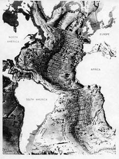 |
The floor of the Atlantic
Ocean.
This is what the Atlantic Ocean would look like with its water
removed. (The use of sonar has allowed us to measure the depth
to the bottom in innumerable places.) The mid-Atlantic Ridge
is quite prominent, but note two of its characteristics. First,
the peak of the ridge is doubled. That is because in the middle
of the ridge is the rift, from which molten rock is extruded,
creating the ridge itself, and, in the past, the entire ocean
floor. Second, the ridge is broken in numerous places by linear
features at roughly right angles to the ridge. These are transform
faults, which represent places where the ridge is offset. Surrounding
the Atlantic are four large tectonic plates: those of North America,
South America, Eurasia (including Europe), and Africa. The Caribbean
Plate, a smaller plate, is barely visible just north of South
America and east of Central America. (Siebold and Berger, 1982) |
It was an early twentieth century German
meteorologist and glaciologist (one who studies glaciers) who
recognized that there was evidence for the movement of continents
that went well beyond the matching coastline contours on either
side of the Atlantic. That evidence included similar fossils and
rock types on continents now far distant from one another. On
the basis of such similarities, Albert Wegener (1880-1930) formulated
his theory of "continental drift": that continents had
somehow drifted from positions they had occupied in the past to
different positions in the present day.
Still, there was no good mechanism to
accomplish such a colossal moving task (though Wegener did indeed
correctly guess that the mechanism was mantle convection, he never
suspected that the crust was divided into enormous plates), and,
for the most part, Wegener's ideas were dismissed. There were
indeed a few geologists who thought his theory had merit, but
they were mostly folks from the Southern Hemisphere, where the
evidence for an earlier consolidation of continents, and their
subsequent "drift," was stronger. But, with the exception
of a tiny number of courageous advocates from the Northern Hemisphere
-- and, at the time (the 1920s and thereafter), the study of geology
was completely dominated by scientists in Europe and the United
States -- Wegener's ideas were considered highly unorthodox, if
not downright loony.
(My friend and former mentor Eldridge
Moores was fond of relating the tale of a Princeton professor
who in the 1950s used to give an annual talk on continental drift,
apparently just to deride it. When evidence supporting the idea
that the continents had indeed moved started accumulating in the
late 1950s and early 1960s, these talks became less and less well
attended, until they finally ceased altogether.)
During and after World War II, partly
prompted by the greater military dependence on submarines, there
was increasing interest in the nature of oceans and the geology
of the ocean floor. Early on, it was noted that the rock that
forms the bottom of the ocean is fundamentally different from
that which forms the continents and continental margins. Continental
rock is highly varied, changing considerably from one location
to another, here sedimentary, there metamorphic, there again igneous:
sandstone, limestone, mudstone, slate, shale, marble, granite,
andesite and many others. Overall, the minerological composition
of continents is close to that of granite. But while ocean basins
may have extensive sedimentary deposits as a consequence of river
runoff and the normal rain of dead organisms into their depths,
the bedrock of the ocean everywhere is basalt.
Basalt is an "extrusive" igneous
rock. It is unlike granite, which is an "intrusive"
igneous rock, produced by the intrusion of granite-composition
magma intruding from below into crustal rocks rather erupting
onto the surface. Granite cools slowly underground, producing
crystals visible to the naked eye. By contrast, basalt erupts
and flows from the earth (hence is "extrusive"), cooling
sufficiently rapidly to prevent large crystals from forming. (To
see the tiny mineral crystals in basalt, therefore, it is necessary
to use a small magnifying lens.)
That the floor of the ocean should be
basalt was for many years a puzzle for geologists. One part of
the puzzle was that the deeper ocean floor seemed young, relative
to the age of the continents. If it was indeed young, at least
by geological standards, then there had to be some mechanism which
had produced it recently -- at least "recently" in a
geologic sense.
Clues to the riddle had to wait until
1957-58, the International Geophysical Year (actually a year and
a half), during which the most extensive oceanographic studies
ever (until then) undertaken were conducted. One of the most notable
revelations of these seafloor studies was that there was a mountain
range on the ocean floor. In fact, it was by far the longest mountain
range on the planet, meandering some 65,000 kilometers (40,000
miles) through the Atlantic, Pacific, Indian, and Arctic Oceans.
Today we refer to this enormous mountain
range as the mid-ocean ridge. It earned the designation mid- because
the section which was originally discovered lies in the middle
of the Atlantic Ocean, but in other oceans it is not so centrally
located. It some places its topography is relatively smooth, in
others quite rugged. Generally, however, it drops gently to the
floor of the ocean (about 4 to 6 kilometers, or 2 1/2 to 3 1/2
miles, deep) from a typical elevation of about 2 to 3 kilometers
(1 1/2 to 2 miles) below sea level.
This ridge, it was discovered, actually
produces the ocean floor, via a central rift which extrudes basaltic
lava. The heat maintains the ridge in its relatively high position;
as its lava cools and moves away from the ridge in both directions
over geologic time, it becomes more dense and compact, and the
ocean basin deepens.
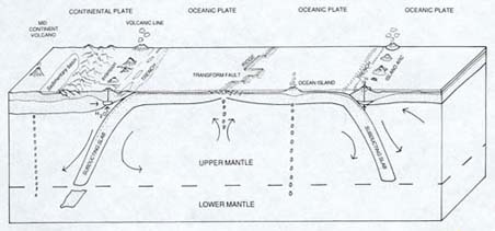
The creation and destruction of ocean
floor. Ocean floor is created
at mid-ocean ridges (shown in the middle of the diagram) and over
millions to tens of millions of years pushes the continents (here,
just one continent) aside. In some places (as along most of the
coast of the Atlantic Ocean), the ocean and adjacent continent
are part of the same plate, and the ocean plate does not drop
down ("subduct"). Elsewhere, as shown here, the ocean
and continent are on different plates, and the ocean plate, being
heavier, subducts. In other areas, ocean plates subduct beneath
other ocean plates (as shown on the right side of the diagram).
Wherever subduction occurs, it produces volcanic activity 150
to 300 kilometers (about 100 to 200 miles) in the direction of
the subduction. (Not all volcanoes owe their origin to subduction,
however, and this diagram shows both mid-continent and ocean island
volcanoes. The blobs below them are rising magma.) Note the long
arrows. These indicate the churning of solid rock (some of it
fully solid; some probably about the consistency of the stiffest
taffy) in Earth's mantle, the presumed driving force for plate
tectonics. (Fowler, 1990)
The actual creation of ocean floor at mid-oceanic ridges explains
why the bedrock of the ocean floor is uniformly basalt, because
it is basaltic lava which is extruded. In addition, the density
of basalt (about 3.3 times the density of water) explains why
the ocean floors should be relatively lower than the continents
(which average about 2.8 times the density of water). The continuous
creation (and destruction) of ocean floor also explains why the
ocean floor is relatively young: after being produced at the mid-ocean
ridges, it moves slowly away and eventually gets recycled down
great trenches back into the interior of the planet. Thus the
most ancient ocean crust, found in the northwestern Pacific, is
at most only about 190 million years old. Much continental rock,
by contrast, is over a billion years old, and some of it is considerably
older.
Ocean basins, therefore, exist because
they are continuously created, and because their rock is denser
and heavier than other rock of the Earth's crust. Just as a more
dense piece of wood floats lower in the water than a less dense
piece does, so also does a large mass of more dense rock "float"
lower on the surface of the Earth than does a large mass of less
dense rock. The density difference between ocean basin rock and
that of continents consequently produces a striking and instructive
contrast between the average elevations of land and ocean floor,
revealed in the hypsographic curve (hypso means altitude or elevation).
The curve shows that the average height of the continents above
sea level is about 3/4 kilometer (about 1/2 mile), while the average
depth of the ocean floor is 3 3/4 kilometers (about 2 1/4 miles).
Thus as long as plate tectonics continues on Earth, there will
be ocean basins -- whether water is there to fill them or not!
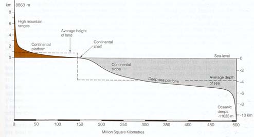 The hypsographic curve (also known as the hypsometric curve). This
curve shows the total global distribution of the land and ocean
floor, according to elevation. Land elevations range from 8863
meters (about 29,000 feet), the height of Mt. Everest, to the
depth of the Marianas Trench, at 11,035 meters (6 1/2 miles) below
sea level. What is particularly interesting about the curve is
that it dramatically reveals that the average height of the land
(about 3/4 kilometer, or 1/2 mile) is vastly different from the
average depth (about 3 3/4 kilometers, or 2 1/4 miles) of the
ocean. This is due to the differing compositions of the rocks
which make up the land (granitic overall) and those which make
up ocean bedrock (basalt). (Duff, 1993, p. 15)
The hypsographic curve (also known as the hypsometric curve). This
curve shows the total global distribution of the land and ocean
floor, according to elevation. Land elevations range from 8863
meters (about 29,000 feet), the height of Mt. Everest, to the
depth of the Marianas Trench, at 11,035 meters (6 1/2 miles) below
sea level. What is particularly interesting about the curve is
that it dramatically reveals that the average height of the land
(about 3/4 kilometer, or 1/2 mile) is vastly different from the
average depth (about 3 3/4 kilometers, or 2 1/4 miles) of the
ocean. This is due to the differing compositions of the rocks
which make up the land (granitic overall) and those which make
up ocean bedrock (basalt). (Duff, 1993, p. 15)
Ocean basins are created, and they are
also destroyed. Logically this has to be the case, because the
Earth is not expanding over time, but remains the same size. After
it is extruded at mid-oceanic ridges, the ocean floor basalt is
carried by plate motion away from those ridges at a pace far slower
(only 5 to 10 cm/2 to 4 inches per year) than that of a snail,
cooling, contracting, and becoming even denser. Eventually, it
drops down beneath other oceanic or continental plates, producing
great submarine trenches up to 11 kilometers (6 1/2 miles) deep
as it does. This process is called subduction, and it is the reason
that the ocean crust is so much younger than that of the continents.
Over the course of hundreds of millions of years, ocean crust
is recycled.
Because ocean floor is created at rifts,
and is destroyed in trenches, the size of an ocean basin depends
on the relative balance of these two processes. In the case of
the Atlantic, rifting and the production of ocean floor continues
as it has for many tens of millions of years, and there is no
significant subduction going on (exceptions being with the Antilles
and the Scotia Arcs, the former in the easternmost Caribbean;
the latter southeast of South America). Thus the Atlantic keeps
growing slowly in size.
By contrast, the Pacific plate, which
is the largest of several plates that comprise the floor of the
Pacific basin, is being created in the eastern and southern Pacific
and being subducted in the north and west. It is believed that
this plate is being destroyed more rapidly than it is being created,
so the Pacific Ocean (particularly the North Pacific) is actually
steadily -- but slowly -- getting smaller.
If this process were to continue, or
if the creation of Pacific plate oceanic crust were to slow or
cease, the ocean basin could entirely disappear. That was indeed
the fate of the ocean plate -- thousands of miles wide -- that
once separated India from the rest of Asia. In the course of about
50 million years, the plate completely subducted (except probably
for a tiny on-land sliver of ocean crust that often remains as
evidence), and India collided with Asia, pushing up the Himalayas.
Using specific rocks that originally formed ocean crust (called
ophiolites), geologists can determine where other ocean basins
which no longer exist once were.
The usual way that earth scientists illustrate
how the plate tectonics process works is by the boiling soup analogy.
Think of a thick soup boiling in a pot. The surface of the soup
has places which are seething, and others where a foamy scud has
formed and collected. The turnover of liquid in the seething places
is extremely rapid,with boiling hot liquid rising to the surface,
pushing outward, and dropping quickly back down (a heating process
is known to physicists and geologists as convection). The seething
liquid often seems to drop down near the places where the floating
scud has accumulated. The scud itself exhibits relatively little
movement, and may form rather large, frothy islands.
In the soup analogy the source of the
heat is an electrical heating element or burning gas. For the
Earth, the heat source is the core.
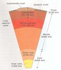 A slice through the Earth. The Earth is divided into three layers (note
arrows on right side): core, mantle, and crust.
The core is extremely hot, kept that way by slow heating
from radioactive elements as well as the great compression from
the mass of material above it. The inner core is primarily solid
iron; the outer core is primarily molten iron. The layers above
are primarily composed of silicates, rocks with a high concentration
of silicon and oxygen. Note that the mantle includes an
inner mantle (not labeled) and an outer mantle, composed of the
asthenosphere and the lithosphere. The asthenosphere is a zone
of partial melting of rock (particularly the low-velocity zone),
which allows the slow movement of the lithosphere above it. The
tectonic plates are usually referred to by geologists as lithospheric
plates, because they include both the uppermost mantle and the
crust. Continental crust is thicker than oceanic crust
(1 kilometer [km] = about 0.6 miles). (Levin, 1991, Figure 6-21,
inset, p. 216)
A slice through the Earth. The Earth is divided into three layers (note
arrows on right side): core, mantle, and crust.
The core is extremely hot, kept that way by slow heating
from radioactive elements as well as the great compression from
the mass of material above it. The inner core is primarily solid
iron; the outer core is primarily molten iron. The layers above
are primarily composed of silicates, rocks with a high concentration
of silicon and oxygen. Note that the mantle includes an
inner mantle (not labeled) and an outer mantle, composed of the
asthenosphere and the lithosphere. The asthenosphere is a zone
of partial melting of rock (particularly the low-velocity zone),
which allows the slow movement of the lithosphere above it. The
tectonic plates are usually referred to by geologists as lithospheric
plates, because they include both the uppermost mantle and the
crust. Continental crust is thicker than oceanic crust
(1 kilometer [km] = about 0.6 miles). (Levin, 1991, Figure 6-21,
inset, p. 216)
The core of the Earth is enormously hot
(about 4300°C/7740°F). It is also under enormous pressure,
which keeps the inner portion of the core solid despite the heat,
though the outer core is liquid. The heat of the core, which is
largely composed of iron, keeps the rocky layer above it -- a
thick layer called the mantle -- hot, and keeps it in extremely
slow, convective motion.
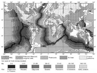 The Ages of Continental and
Oceanic Crust. This map stunningly
reveals the difference between the crustal ages of continents
and ocean basins. First, note the distinctive bands which indicate
the age of the ocean floor. The boxes in the lower part of the
key specify the age of the ocean floor's crust: it ranges from
0 Ma (millions of years ago) to about 160 Ma. (The ages of some
of the crust near Indonesia and south of South America is shown
in white. Its age has not yet been determined.) The darkest "stripes"
indicate the youngest ocean floor; this is where new ocean floor
is being extruded as lava on the mid-ocean ridges. The offsets
are transform faults. By contrast, continental crust
ages are highly variable, ranging from the Archean (the oldest,
up to 3.8 billion years old) to the Paleozoic and Mesozoic (543
to 65 million years old; an orogenic belt is a mountain belt).
Proterozoic rocks range in age from 2.5 billion to 543 million
years old. Interior platforms vary in age, but may be from 2.5
billion years old to relatively recent. Two areas of continental
rifting are shown: that in the American Southwest (mostly Nevada
and southeastern California), and that in east Africa. (The upper
set of boxes indicate continental crust ages.) (Moores and Twiss,
1995, p. 30)
The Ages of Continental and
Oceanic Crust. This map stunningly
reveals the difference between the crustal ages of continents
and ocean basins. First, note the distinctive bands which indicate
the age of the ocean floor. The boxes in the lower part of the
key specify the age of the ocean floor's crust: it ranges from
0 Ma (millions of years ago) to about 160 Ma. (The ages of some
of the crust near Indonesia and south of South America is shown
in white. Its age has not yet been determined.) The darkest "stripes"
indicate the youngest ocean floor; this is where new ocean floor
is being extruded as lava on the mid-ocean ridges. The offsets
are transform faults. By contrast, continental crust
ages are highly variable, ranging from the Archean (the oldest,
up to 3.8 billion years old) to the Paleozoic and Mesozoic (543
to 65 million years old; an orogenic belt is a mountain belt).
Proterozoic rocks range in age from 2.5 billion to 543 million
years old. Interior platforms vary in age, but may be from 2.5
billion years old to relatively recent. Two areas of continental
rifting are shown: that in the American Southwest (mostly Nevada
and southeastern California), and that in east Africa. (The upper
set of boxes indicate continental crust ages.) (Moores and Twiss,
1995, p. 30)
The scud is very much like the continents,
accumulating gradually but changing little over time. The seething
liquid, by contrast, is like the ocean basins, in a continual
change. The soup analogy is a useful one but obviously has some
serious limitations. Unlike the soup, the Earth has a thin but
solid crust. But the soup clearly illustrates a basic geologic
process called fractionation. The constant churning of the soup
separates its lighter parts (that is, the lighter fraction) as
scud, while the thick and heavy liquid (the heavier fraction)
continues to seethe.
Another limitation of the soup analogy
is that soup time is extremely short compared to geological time.
The surface of the geological "soup" -- the tectonic
plates, that is -- only moves a few inches per year at most. Moreover,
there is very little liquid involved. Yes, lava does ooze out
of rifts in the mid-ocean ridges, and spew or blast out of various
types of volcanoes, but most of the movement of the earth's surface
does not involve molten rock. Instead, most moving rock is either
quite solid, or, down below where the temperatures are hotter,
perhaps the consistency of stiff taffy. In fact, it is this very
stiffness which explains why this sort of geologic movement is
excruciatingly slow.
It is possible to understand how ocean
basins formed by looking at how they are currently forming. (Surprisingly,
perhaps, that process did not just take place in the geologic
past, but actually does go on today!) The process starts when
an elongated "crack" begins to open in a continental
area. This "crack" geologically is called a fault, and
usually is not a real physical opening in the earth, no more than
California's San Andreas Fault is. There are lots of faults in
the rocky crust of the Earth, some big (stretching a thousand
or more kilometers -- 600 or more miles) and some quite small
and local (just a few meters --yards), but the kind of fault which
eventually produces an ocean basin is both rare and unusual. It
is produced by forces quite deep in the earth, extrudes lava as
it grows, and is beset by earthquakes throughout the millions
of years of its existence.
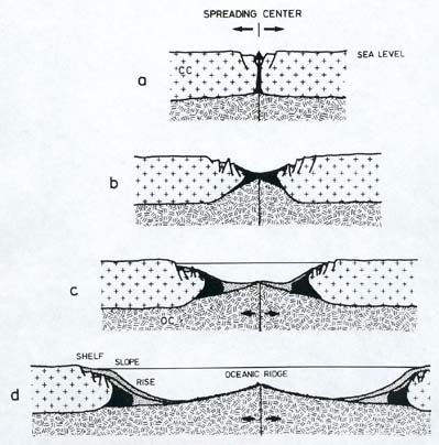 Creating an ocean. The process of creating an ocean begins with
rifting (the "spreading center" shown here). Early on,
the rifting produced only low-lying areas (b), sometimes hosting
freshwater lakes, as those of East Africa. As rifting continues,
the low-lying area eventually makes contact with the ocean, and
floods with seawater (c). This is what has happened with the Red
Sea. As rifting continues further, a wider and wider ocean is
produced. In a similar fashion, the Atlantic was created in about
180 million years. (Seibold
and Berger, 1982)
Creating an ocean. The process of creating an ocean begins with
rifting (the "spreading center" shown here). Early on,
the rifting produced only low-lying areas (b), sometimes hosting
freshwater lakes, as those of East Africa. As rifting continues,
the low-lying area eventually makes contact with the ocean, and
floods with seawater (c). This is what has happened with the Red
Sea. As rifting continues further, a wider and wider ocean is
produced. In a similar fashion, the Atlantic was created in about
180 million years. (Seibold
and Berger, 1982)
A few million years after it has begun
to open, it is a low-lying area usually surrounded by volcanic
mountains or highlands. Being low-lying, it will fill with water.
A glance at a map of eastern Africa reveals just such a landscape.
All along the eastern border of Congo, and continuing along the
eastern border of Malawi, there is a string of elongated lakes,
smaller in the north (Lake Albert, Lake Edward, Lake Kivu), but
considerably larger and longer to the south (Lake Tanganyika,
Lake Nyasa). These freshwater lakes help define the long system
of faults known as the East African Rift, because it is undergoing
the geologic process known as rifting.
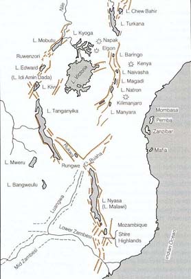
| |
| From rift
to ocean. The continent
of Africa is slowly being torn apart along the East African Rift.
The map on the left shows, in brown, the location of the rift.
Note that many of the region's lakes have parallel brown lines.
These represent the walls of the grabens in which the lakes lie.
A graben, as shown in the diagram on the upper right, is a block
of crust that has dropped down relative to the surrounding area.
Grabens are produced as the crust is pulled apart and broken.
Here the pulling is the result of the movement of East Africa
plate toward the east, that is, in the direction of the Indian
Ocean. (The current situation is similar to that shown in b of
the previous diagram.) As rifting continues, this area will eventually
resemble that of the Red Sea, shown in the diagram on the lower
right. (The arrows indicate the direction of rifting.) Newly
created ocean floor (basalt) is indicated by the stippling. (This
situation is like that shown in c of the previous diagram.) (East
Africa map from Duff, 1993, Figure 29.9, p. 672; Graben diagram
is from Press and Siever, 1986, Figure 4-27, p. 93; Red Sea map
is from Duff, 1993, Figure 29.7, p. 670.) |
As the rifting process continues, the
rift eventually meets the sea, and the freshwater is replaced
by the saltwater of the ocean. Look further north on that map
of Africa, and you will notice the Red Sea. Here we see the rifting
process at a later, more developed stage. The sea is connected
to the ocean; it contains salt water; it is longer and wider than
the lakes of the East African Rift. On the other side of the globe,
in North America, Mexico's Gulf of California displays rifting
at a similar stage of development.
Such were the origins of the Atlantic
Ocean. About 180 million years ago, what we now refer to as Africa
and Europe were attached to and part of the Americas. Then rifting
began, first in the north central area, and then, tens of millions
of years later, in the south. The great S curve of the Mid-Atlantic
Ridge had begun to create the ocean floor that would push Africa
and Europe roughly 2500 kilometers (1500 miles) to one side, and
the Americas roughly 2500 kilometers to the other. The Atlantic,
currently about 5000 kilometers (3000 miles) across, continues
to grow, adding a few inches to its width each year.
The plate tectonics process produces
the major features of the ocean floor.
Adjacent to the continents are the continental
margins; these are underwater extensions of the continents, composed
of continental-type rocks rather than oceanic basalt, and largely
covered with sediment washed into the ocean by the rivers of the
land. Further from the continents lies the great deep of the ocean,
called the abyssal plain (4 to 6 kilometers deep, or 2.5 to 3.5
miles), which, because it is so distant from the continents, gets
rather little continental sediment, but often receives a slow,
steady rain of organic debris from the overlying ocean.
Immediately off the edges of the continents
lie the continental shelves, situated in relatively shallow water.
In some places, such as the Atlantic coast of the Americas, the
shelf is relatively wide, extending as much as about 100 kilometers
(60 or so miles) out. In others, as along the Americas' Pacific
coast, the continental shelf is relatively narrow, dropping off
only 10-15 kilometers (6-9 miles) offshore. Some shallow seas
(called epicontinental or epeiric seas), like Hudson Bay in North
America, and the Ross and Weddell Seas on the edge of Antarctica,
also are underwater portions of continents.
Geologically, the continental shelf is
defined as that part of the continental margin that is between
the shoreline and the continental slope (or, when there is no
distinct continental slope, a depth of 200 meters). It is characterized
by a gentle downward gradient of 0.1°. Shelves are not only
adjacent to continents and under relatively shallow water, but
they also share the general geology of the continents: rock compositions
are similar, granitic in overall composition, and of the same
general age.
Further from the continent is the continental
slope, the more distant portion of the continental margin. The
slope tends to be fairly narrow compared to the continental shelf,
but it lies deeper and has a gradient of about 3 to 6%. Though
steeper than the adjacent continental shelf, and even occasionally
as steep as 15%, these gradients are certainly not precipitous.
The continental slope drops from the continental shelf (at a depth
of about 200 meters, or 600 feet) to depths of several kilometers.
(The slope and the "passive basins" of the same depth
are the parts of the ocean where, as we will see, methane hydrates
are found, because temperature and pressure conditions are right.
With hundreds to thousands of meters [600 to about 6500 feet]
of water overlying them, and with the frigid temperatures at such
depths, conditions allow the formation and preservation of these
exotic, icy substances.)
Still further out there may be a continental
rise, with a generally smooth topography and a gently inclined
gradient of from 0.05% to 2.5%. The continental shelf and slope
may be incised by submarine canyons, particularly in areas where
large rivers now or in the geologically recent past have cut into
submarine sediments as they deliver their waters to the ocean.
The continental rise represents the area of the ocean floor where
the remaining muddy sediment derived from rivers and continents
(that which has not been left behind on shelf or slope) is deposited.
Rises are common to passive margins (as along the Atlantic: see
below), but not to active ones (as along the Pacific Northwest).
The deepest parts of the ocean basins,
however, constitute a striking contrast to the parts of the oceans
which are shallower and closer to land. They are extremely deep,
dark, and intensely cold. Because these ocean basins are generally
flat, and what topography there is is at most gently inclined,
they are referred to as abyssal plains. On average, they are several
(four to six) kilometers deep. Their extreme depth provides no
natural light. Their water temperatures are about or only slightly
above 0°C (32°F). In fact, their water may actually be
below the freezing point of water -- pure water, that is. Because
salt lowers the freezing point of water, highly saline seawater
can remain liquid at temperatures down to about two degrees below
zero Celsius (that is, to almost 28.4°F).
These, then, are the major features of
the ocean floor: the rifts/ridges, which actually produce the
bedrock of the ocean basins, the deep floor itself, the zones
where subduction is taking place, and the continental margins.
Continental margins, however, are not everywhere the same. Where
continents are overriding the subducting oceanic plates, there
is a good deal of earthquake and volcanic activity. These margins
are called active margins, and where they exist, the continental
margins are narrower. This is why continental shelves on the Pacific
coast of the Americas are less wide than those of the Atlantic
coast. Offshore they have (or in the geologically recent past,
did have) trenches where ocean crust is (or recently was) subducting.
The continental margin of Northwest Coast
of the US is an example of such an active margin. Much of the
California coast is prone to earthquakes, both from the San Andreas
Fault and many others. To the north is a major subduction zone,
just off the northern California coast and along those of Oregon,
Washington, and British Columbia. This coast can have rare, but
quite powerful quakes. Inland from the coast is the Cascade chain
of volcanoes, stretching from Mounts Lassen and Shasta in the
south to Mount Baker near the Canadian border. These features
of the West Coast are the consequence of the continuous movement
of the North American continent as it overruns the Juan deFuca
plate; the movement churns up sediments along the coast but keeps
the margin narrow.
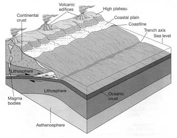
| Andean-type continental
margin, also referred to as an active margin. Named after the Andes Mountains of western
South America, another example is that along the coasts of northern
California, Oregon, Washington and British Columbia. There, an
ocean plate (the Juan deFuca plate) drops down ("subducts")
beneath the North American continent, producing volcanoes (the
Cascade range). (Moores and Twiss, 1995, p. 46) |
 |
By contrast, the continental shelves
along both sides of the Atlantic (including the Americas, Europe,
and Africa) are relatively wide. Once rifting and the creation
of the Atlantic Ocean basin had pushed the continents some distance
to each side, the continental margins became quiet, or passive.
Although there is some occasional earthquake activity along the
North American continental margin (there was a major quake in
the Boston area in the early 18th century, for example, and another
in Charleston, South Carolina in the late 19th), such activity
is rare. And, obviously, there are no volcanoes.
| Atlantic-type continental
margin, also called a passive margin.
This cross-section through land and ocean reveals that no subduction
or subduction-related volcanism is occurring. Continental curst
and ocean crust are part of the same plate. The "intrusions
and extrusions" are remnants of the rifting activity which
produced the ocean basin. (Moores and Twiss, 1995, p. 45) |
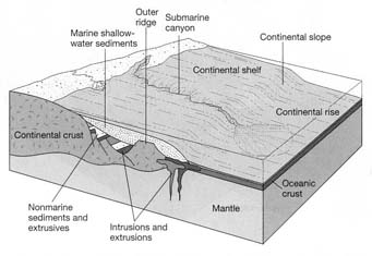 |
Plate tectonics is the central integrating
concept of geology, just as evolution is the central integrating
idea of biology. I employ the phrase "central intergrating
concept" rather than the term "theory" because
that term is both misunderstood and abused. The term "theory"
is misunderstood because it leads some people to think that something
described as a "theory" is a mere air-headed idea without
foundation in reality or facts to back it up. Nothing could be
further from the truth. Moreover, the use of the term "theory"
allows opponents -- who almost universally have no or little knowledge
of the myriad facts that support the concept -- to disparage theories
as without basis. Both plate tectonics and evolution have enormous
quantities of evidence to support them; moreover, they explain
things which would simply be without explanation otherwise.
RETURN TO CONTENTS
RETURN
TO PERMIAN WORLD SECTION